Cold Water and Hot Steel

I’d like to introduce the world’s largest integrated steelmaking complex, the ArcelorMittal Indiana Harbor steel works in East Chicago.

ArcelorMittal Indiana Harbor steel mill

I say I’d like to – but it’s just too big. Too much. Too hard to grasp. And more importantly, too tightly sealed to public access.

ArcelorMittal Indiana Harbor steel mill

ArcelorMittal Indiana Harbor steel mill

All I can truly offer is a series of stolen glances, quick flashes gained by trooping doggedly around northwest Indiana over the years, over and over – testing the limits of every road, every shoreline, every park, every overpass, every parking lot. I’ve pushed my zoom lenses and my camera’s sensor to their limits, and probably turned the head of every security guard within a mile of the lake’s edge, for glimpses into this astonishing industrial kingdom of ash and fire.

ArcelorMittal Indiana Harbor steel mill

Here I present the results.

ArcelorMittal Indiana Harbor steel mill
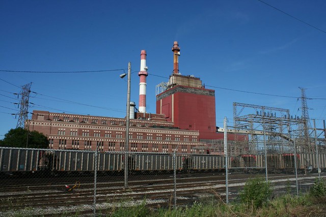
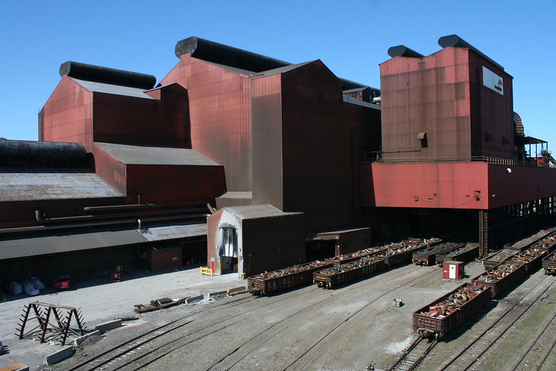
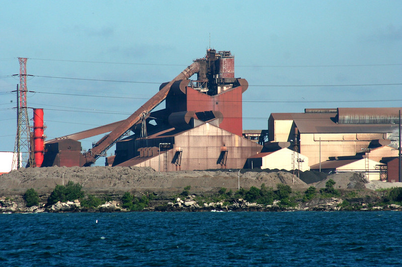
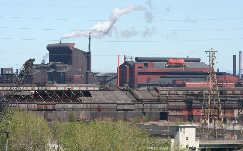
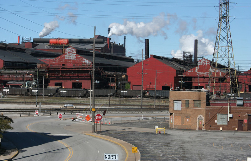
One of the facility’s several blast furnaces, where raw ores – fed in at the top, hence all the conveyor belts – are heated and combined into a liquid metal form. AcelorMittal’s website alternately states that there are 3 or 5 blast furnaces on the site.

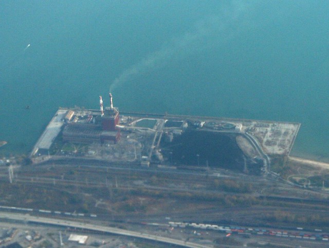
I cannot say I understand this place, but I am fascinated by it. Flying over it in Bing’s aerial views, the vast size becomes apparent. Hundreds of acres of buildings, jammed one against the next. In true Chicago fashion, they are enormously long, repeating themselves endlessly bay after bay.

ArcelorMittal Indiana Harbor steel mill

What is now ArcelorMittal Indiana Harbor began over a hundred years ago, as the Inland Steel plant. Inland Steel – now most famous for their landmark Modernist headquarters building in downtown Chicago – was formed in 1893, and began development on the Indiana Harbor Canal site in 1902. The business grew over the next 15 years to include a lease on a Minnesota ore mine and a lake freighter division, ensuring in-house control over supply and shipping of raw materials, an integration strategy that would be completed by World War II’s end and last into the 1990s. Across the 20th century, the plant would continuously expand and modernize, while producing a huge variety of goods – from railroad spikes to World War II materiel. Post-war, a large portion of its output went into automobiles. At its peak, 25,000 people worked at the plant. The company was purchased in 1998, becoming Ispat Inland. Mergers in 2005 and 2007 created ArcelorMittal, an international corporation that is the world’s largest steel company and current owners and operators of the facility.

ArcelorMittal Indiana Harbor steel mill

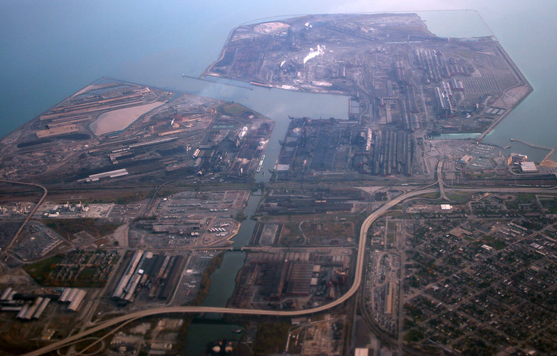
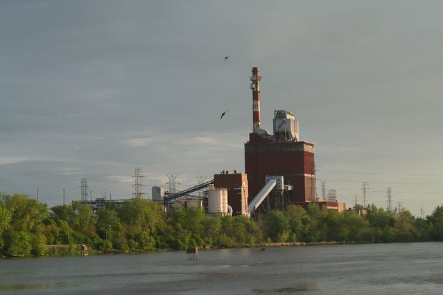
The huge complex is mostly sited on an artificial peninsula jutting out into Lake Michigan, with the Indiana Harbor Canal running down the middle. Many acres are covered with buildings; the site is also criss-crossed with railroad tracks, roads, overpasses, material storage lots, and a huge variety of industrial structures. In the 2010 photograph above, the now-demolished Cline Avenue – aka Indiana State Road 912 – snakes its way around the inland portion of the facility. Marktown is visible at lower left; just out of the frame to the left is the giant BP refinery at Whiting.

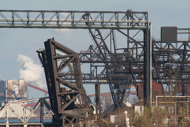
The site is also a bottleneck for railroads as they muscle their way into Chicago; at one point, nearly half a dozen rail bridges crossed the canal. Only one remains in full-time service, but it sees heavy use, with multiple freight trains crossing it hourly.

ArcelorMittal Indiana Harbor steel mill

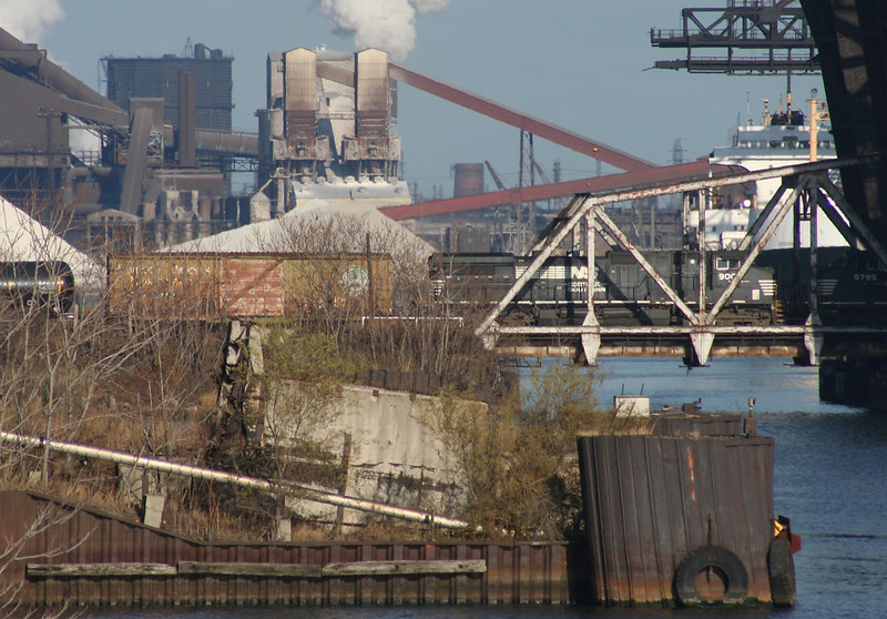
Raw materials arrive primarily by boat; the wide mouth of the canal can handle full-size lake freighters and has docking space for several. Huge ore cranes lining both sides of the canal unload arriving ships.

I could gaze at this forever.

ArcelorMittal Indiana Harbor steel mill

One result of having such a huge complex is that outdated buildings and equipment are often abandoned in place and may stand for years, untouched, while business proceeds around them. It’s not like there are neighbors to complain! Large expanses of the site may deteriorate for years and even become overgrown.

ArcelorMittal Indiana Harbor steel mill

Above: remains of an abandoned blast furnace alongside the canal in 2004. Already stripped of their support infrastructure, the hearths were dismantled shortly afterwards.

ArcelorMittal Indiana Harbor steel mill

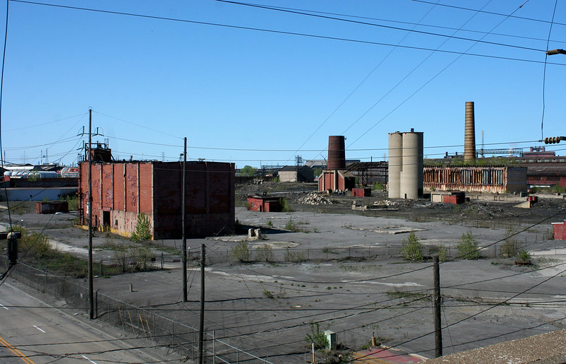
Above: remains of Inland Steel’s coke ovens and by-products processing plant. Inland ceased coke production in 1993, but the abandoned ovens still stand, with grass growing on the roof.

ArcelorMittal Indiana Harbor steel mill

Long-abandoned ramp and trestle alongside Dickey Road. BP’s Whiting refinery looms in the background.

ArcelorMittal Indiana Harbor steel mill

Half-demolished buildings can hang around for years:

ArcelorMittal Indiana Harbor steel mill
An abandoned building in 2004.

ArcelorMittal Indiana Harbor steel mill
The same building – most of it, anyway – in 2013.

ArcelorMittal Indiana Harbor steel mill

ArcelorMittal Indiana Harbor steel mill
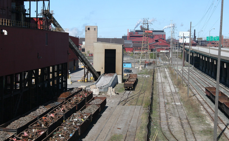
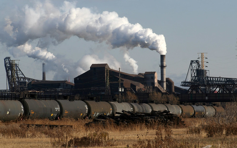
Recycling steel is a major part of the contemporary steel business. Gondolas are stored here, full of scrap steel awaiting its fate in the arc furnace. The now-demolished Highway 912 overpass stands at right.

ArcelorMittal Indiana Harbor steel mill
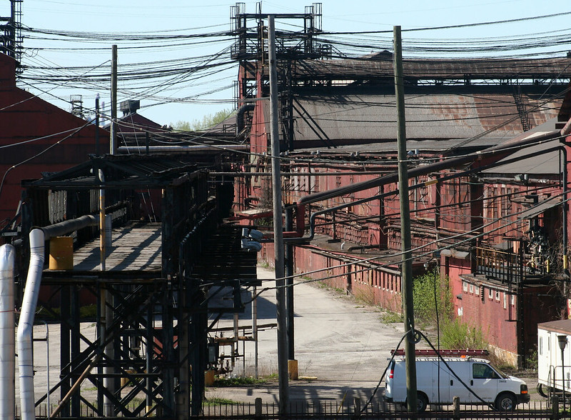
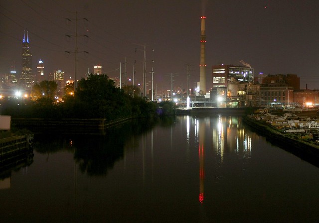
Legions of criss-crossing electrical lines speak to the vast power requirements of the complex.

ArcelorMittal Indiana Harbor steel mill
And did we mention that there’s a significant work of architecture in the midst of all this industrial madness? The main office building on the site is a lovely 1930 work by Graham, Anderson, Probst & White. It’s an Art Deco beauty in red-brown brick, with floral cartouches atop each bay and twin towers punctuating its skyline.

The steel industry has changed dramatically since its last great domestic peak in the 1970s. Automation has vastly reduced the number of workers required to produce a unit of steel, leading to devastating unemployment in mill-dependent towns like nearby Gary. Evolving technologies have rendered many US facilities obsolete, leading to the kind of abandonment seen here and there on the Indiana Harbor campus. And international competition has required steel companies to be agile and flexible to survive. Outsourcing coke production was just one of a number of maneuvers by Inland and its successors to survive the times.

ArcelorMittal Indiana Harbor steel mill

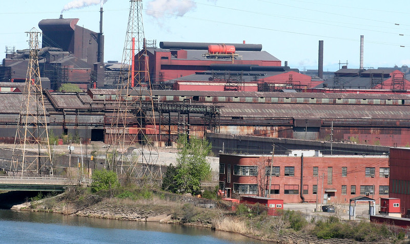
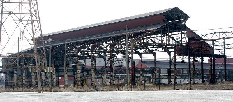
Rolling mill buildings. In these and other buildings, the newly formed steel is pressed or rolled into bars and other shapes of uniform thickness.

Forgotten Chicago offered a tour of the Indiana Harbor Canal in summer 2013, which sailed right through the middle of the plant; no word yet on when a repeat tour might be offered. Till then, I have more photos of the plant at my Flickr space.

ArcelorMittal Indiana Harbor steel mill

Vertical Lift Bridges

In the long-delayed Part Three of a look at Chicagoland’s moveable railroad bridges, we’ll visit all ten of Chicago’s vertical lift bridges – starting at the far south and moving north.

Vertical lift bridges consist of two towers housing counterweights and cable systems, with a moveable span between them which rises directly up when needed. They are often used for longer crossings and places where a waterway must be crossed at an angle. The towers, often reaching up to 200′ in height, are highly visible in Chicago’s flat landscape.

CSX / Joliet Railroad Bridge, Joliet – 1932
IMG_7858

Nearly in the center of downtown Joliet, this bridge still sees occasional use by trains. It remains in the open position until needed by a train.

IMG_7909a

The bridge is one of a long sequence of moveable bridges lining the Joliet River as it passes through town. Barges necessitate the frequent opening of the bascule bridges seen in the distance.

IMG_7836

IMG_7865

IMG_2614

Joliet Railroad Bridge at Bridgehunter.com

Canadian National Bridge – north of Joliet
IMG_7954

Not easily accessible, this bridge sees frequent rail traffic on the CN main line.

IMG_7944

CN Des Plaines River Bridge at Bridgehunter.com

Torrence Avenue Bridges – 1938, 1968IMG_7556

Two bridges standing side by side dominate the landscape of S. Torrence Avenue, visible from miles away. Much of the surrounding terrain is marshland and remains undeveloped, lending further prominence to these two massive structures.

IMG_7348a

IMG_0914a

The lowered bridge, recently rehabilitated and still in active use, is a road bridge, carrying Torrence Avenue over the Calumet River. It was built in 1938. In the photo above, it appears in its previous steel gray paint; post-renovation, it sports the common Chicago maroon.

The raised bridge is an abandoned railroad bridge, built in 1968. During renovation of the road bridge, the rail bridge was lowered and used as a bypass for the road.

IMG_7370a

IMG_7588a

IMG_7532a

IMG_7456a

Torrence Avenue Bridge at HistoricBridges.org

Chicago and Western Indiana Railroad Bridge at HistoricBridges.org

Norfolk Southern Bridge (originally Nickel Plate Road), Calumet River, 1971
IMG_7469a

A double-track rail bridge over the Calumet River, only a few hundred yards’ distance from the Torrence Avenue bridges.

IMG_7376

DSCF0495a

Norfolk Southern Calumet River Bridge at HistoricBridges.org

Multiple bridges, Calumet River – 1912-15
DSCF0194a

A total of five bridges once spanned the river at this location – 4 vertical lifts, and a single bascule bridge. One of the lift bridges was demolished in the 1960s, and two more are abandoned, but they still form one of Chicagoland’s most impressive industrial sights.

IMG_5073

In the view above, the one active bridge stands alone on the right; the gap marks the location of its lost twin. These two built for the Pittsburgh Fort Wayne & Chicago Railroad – eventually assimilated into its parent company, the Pennsylvania Railroad.  The demolished bridge was removed in 1965; two workers were killed when a crane failed, dropping the span into the river.

At center are two abandoned bridges originally built for the Lakeshore and Michigan Southern railroad, which soon after became part of the New York Central. The Pennsylvania and the New York Central merged into Penn Central in 1968, rendering these two obsolete and leading to their abandonment. The bridge has since passed from Penn Central to Conrail to Norfolk Southern.

The left-most bridge is the half-destroyed bascule bridge, built by the Baltimore & Ohio Chicago Terminal Railroad.

IMG_5109a

The towers are around 190 feet high, capped with massive cable winding sheaves that are 15 feet in diameter. The Chicago Skyway bridge affords an excellent, if all too brief, view of the bridges’ upper workings.

IMG_5242a

IMG_5104

The Calumet River Bridges at HistoricBridges.org

Canadian National / Elgin Joliet & Eastern Bridge 710 – Calumet River, 1974
IMG_7638a

Spanning the Calumet River just before it empties into Lake Michigan, this single-track span is the newest vertical lift bridge in the region.

It’s not clear that the bridge is abandoned, but it clearly sees very little traffic.

IMG_7666a

IMG_5628a

EJ&E Calumet River Bridge at Bridgehunter.com

Pennsylvania Railroad Bridge 458 – Chicago River, 1915
IMG_7275

The heaviest lift bridge in the world when completed, this still-active bridge crosses the Chicago River south branch at Chinatown, carrying many Amtrak trains daily. It is raised twice a week during boating season.

Dscf9865a

IMG_5038a

IMG_5035

IMG_1020a

IMG_8644a

Canal Street Bridge at HistoricBridges.org

Chicago’s Rail Bascule Bridges

Swing bridges are quiet curiosities – if it seems odd that a bridge should move, at least it’s only moving sideways.

Bascule bridges, by contrast, are utterly bizarre. If bridges aren’t supposed to move in the first place, then they really are not supposed to upend themselves into the air. That a flat sidewalk or roadway should become a vertical surface defies all logic and expectation.

Chicago’s roadway bascule bridges – including all the ones downtown – are elegantly slender, partly by necessity – crowded downtown streets don’t have a lot of room to spare. By contrast, the area’s numerous rail bascule bridges sport gigantic superstructures and enormous hanging counterweights, visually spelling out the defiant nature of their function – the titanic forces required to span a waterway, support a train, and occasionally turn the whole affair on its side.

Pennsylvania Railroad Western Avenue Bridge
IMG_6559a

Variously known as the 8-track bridge or the scissor lift bridges, this complex conglomeration of steel is one of Chicago’s most unique sights. Just south of Western Avenue, the “bridge” is actually four bridges standing side by side, supported by common foundations. Each originally carryied two sets of railroad tracks. The western two bridges – seen above, rusty brown from lack of maintenance – are now abandoned, with tracks removed. The eastern two, however, still see many freight trains a day.

IMG_4581

The bridge type is known as a Scherzer rolling lift bridge – to open up, the entire span would literally roll back on the rounded arcs visible, pulled down by the massive counterweights hanging from the structure. Each bridge is a single-leaf structure, though the close spacing, alternating opening directions, and shared foundations have lead some sources to refer to them as double-leaf.

The 8-track bridges are no longer operable, and their motors have been removed. Curiously, there are no images online of the bridges in the open position, nor any indication of when the bridges last opened. Fixed in their closed position, they constitute the lowest bridge on the canal, with only 17 feet of clearance – a landmark by which boat clearances are measured by pleasure cruisers doing the various waterway circuits that pass through Chicagoland. Boats unable to pass below them must instead take the Cal-Sag canal to reach Lake Michigan.IMG_9824a

IMG_9842

IMG_4921

The nearby Western Avenue road bridge was itself a lift bridge, with an impressively massive superstructure that has since been removed – see images here.

Further reading on the 8-track bridges:


Chicago and Alton Railroad Bridge
IMG_6534A

This smaller bridge sits next to an Orange Line El stop, and spans a short branch of the river that run southward before abruptly terminating north of Pershing Street. Bridgehunter.com dates it to 1906.

IMG_4888a

IMG_4879a

IMG_4853
Further reading on the C&A Bridge:


St. Charles Air Line Bridge
Baltimore & Ohio / Chicago Terminal Railroad Bridge
IMG_8665a

The most monstrously huge of them all, this pair of lift bridges crosses the Chicago River just south of Roosevelt Boulevard.

The northern bridge – built for the Baltimore & Ohio and the Chicago Terminal Railroad, in 1930 – is long abandoned and permanently raised, the tracks leading to it long since vanished. (ref 1)

IMG_7311

The southern bridge, originally serving the St. Charles Air Line Railroad, was built in 1919, moved and shortened in 1930, and still sees Amtrak traffic today. (ref 1) (ref 2)

The 1919 bridge was originally a few hundred feet east, as was the river itself. When the river was straightened, the 1930 bridge was built, allowing the older bridge to be moved alongside it without disrupting rail traffic. The older bridge was shortened at this time since it had less river to cross.

IMG_8912a

If you’re ever lucky enough to see this mass of steel in motion, you’ll discover that the heavy angled piece is actually hinged at both ends – the counterweight section hoists the bridge up not as a contiguous piece, but through this pivoting system. The city has posted an amazing video of it, and many other bridges in motion, here.

The abandoned 1930 bridge operated through the same system, known as a Strauss Trunnion after the engineer who designed it.IMG_3696a

IMG_3668A

IMG_6952a

Further reading on the St. Charles Air Line Bridge:

Further reading on the B&O Bridge: HistoricBridges.org


  • Deering BridgeP5020178aIMG_7428Serving the Union Pacific North Metra line, the Deering Bridge was built in 1916, replacing an earlier swing bridge on the site. (ref)Further reading on the Deering Bridge: HistoricBridges.org

Kinzie Street Chicago & Northwestern Railroad Bridge
IMG_0974a
The other lift bridges are mostly far from the city center, in fairly out-of-the-way spots; not so the former C&NW bridge, which sits right in the middle of downtown. This bridge once served the industries near the lakefront, its tracks running under the Merchandise Mart to Navy Pier. The last customer was the Chicago Sun-Times; the bridge was lowered for paper deliveries to the printing presses. Since the Sun-Times closed up shop in the early 2000s (the site now replaced by the Trump Tower), this bridge has been permanently raised. (ref 1) (ref 2)

IMG_6065a

P5020226a

Further reading on the Kinzie Street C&NW Bridge:


Multiple bridges, at the Indiana Harbor Canal

IMG_4380a

At a narrow stricture point, multiple rail lines once crossed the Indiana Harbor Canal on their approach to Chicago – a total of ten lines on five bridges. Only two of the bridges remain in service today, carrying three tracks and seeing heavy freight traffic from BNSF and Norfolk Southern, as well as eastbound Amtrak trains.

The majority of trains pass over the Norfolk Southern bridge, the silver-whitish one in the foreground. Behind it, the bridge with the greenish tint is an Elgin, Joliet & Eastern bridge, now owned by Canandian National.  The box girder bridge was previously the Baltimore & Ohio main line; the two trestle bridges in front of it carried the New York Central. (ref)  The structures in the background are ore unloaders for the steel mill.

IMG_8767a

A sixth one was built in 2011 – a bright blue bascule bridge that directly serves the ArcelorMittal steel mills.

IMG_7748

It’s barely visible above, but a clear shot may be seen here.

This fascinating group is difficult or impossible to reach without crossing a great deal of private property, or else taking a boat down the Indiana Harbor Canal – which, it just so happens, you can do this July if you take Forgotten Chicago’s Indiana Harbor Canal tour.


And just south of this group –

EJ&E Whiting Line Bridge No. 631
IMG_7765a

A much smaller and isolated bridge, still operable and in use. A small example of the Sherzer Rolling Lift style.

IMG_5819a

IMG_5731b
Further reading on the EJ&E Bridge: BridgeHunter.com


Baltimore and Ohio Railroad Bridge – at the Calumet River
IMG_5082
This unfortunate stump of a bridge met a colorful end when a massive lake freighter hit it in 1988. The span was damaged beyond repair, and removed; only the counterweight portion remains in place today. (ref)

IMG_5081

IMG_5073It stands alongside three vertical lift bridges… a topic we’ll cover next time!

Further reading on the B&O Calumet River Bridge, including photos of the accident that destroyed it: HistoricBridges.org

Swing Bridges of the Sanitary and Ship Canal

The Chicago Sanitary and Ship Canal has the least appealing name imaginable, but it draws interest for its remarkable history – as a feat of engineering, as a center of industry, and as a major geographic feature for southwestern Chicago. It is one of those rare elements that truly disrupts the marching grid of Chicago’s streets.

IMG_9170a

The Sanitary and Ship Canal from the air, with railroads, industry and the Stevenson Expressway alongside.

Railroads, of course, are fewer in number than roads, and also heavier and less agile. The result is that a large number of remarkable railroad bridges cross the Sanitary and Ship Canal – all of them originally designed to move for ship traffic when needed.

With one major exception, movable bridges over the Chicago river and its associated canals fall into two groups: lift bridges, where the bridge raises into the air, and swing bridges, where the bridge rotates out of the way.  Today, we’ll visit a few of the swing bridges.

Almost none of the canal’s movable bridges remain operable today; many have had their machinery removed. This raises a curious question: when was each bridge last opened, and which one was shut down first? Deactivating a single bridge would essentially restrict boat height for the entire canal to the maximum clearance of that bridge. At what point was the canal judged no longer important enough to require maintenance of the bridges?

Santa Fe Railroad Bridge – near Harlem Avenue
IMG_9948

Now owned by the Santa Fe’s successor BNSF Railroad, this swing bridge sits perhaps a quarter mile northeast of Harlem Avenue and still sees frequent traffic. The Historic American Buildings Survey Engineering Record dates it to 1899, when the first segment of the canal was constructed.

IMG_9934a

IMG_9925

This bridge appears as the opening image of Wikipedia’s page for the canal – standing high and dry, before the canal had been opened and filled.

Chicago and Western Indiana Railroad Bridge – northwest of Cicero AvenueIMG_9731a

The least accessible of these bridges, the Cicero rail bridge is another swing-span bridge with a mid-stream pivot, built in 1899 as part of the canal’s construction. In the view above, the Ciero Avenue road bridge is visible beyond the rail bridge.IMG_6604a

Chicago and Western Indiana Railroad Bridge
IMG_9787a

Sitting north of Pulaski Avenue, this is another original 1899 bridge that dates to the canal’s original construction. It is a two track bridge; only one track remains, and that one sees only occasional use.IMG_9761

IMG_9791a

Kedzie Avenue BNSF Railroad BridgeIMG_9796a

Originally built for the Chicago, Madison & Northern Railroad, this bridge  stands just north of Kedzie Avenue and crosses the canal at a sharp angle; in fact, the tracks cross over Kedzie itself just a hundred yards or so later.  The Kedzie bridge is another swing-span bridge with a center pivot point; it has a more substantial central framework than its neighbors to the south.

This two track bridge remains in heavy use today.

Chicago’s Coal Fired Power Plants

Chicagoland’s biggest power plants  – particularly Fisk, Crawford and State Line – are fascinating behemoths. They are madcap assemblages of machinery and ad hoc construction, as tall as a skyscraper, with additions and alterations accumulated over many decades of operation. All three started from a core of massive, pre-Depression, low-rise masonry buildings, embellished with varying degrees of architectural detail; all three exploded upwards as part of LBJ-era expansion programs.

IMG_7811a

Today, all three are facing closure due to their outdated coal-burning systems, which – despite improved burning techniques and pollution controls – make them the largest point sources of air pollution in and around Chicago. But for me the single uniting factor for them all is something far more mundane – the red-painted metal cladding, with International Style ribbon windows, that distinguishes their Mid-Century additions.

IMG_7783

Those additions are mostly built as vertical additions to existing older buildings; they accommodate huge multi-story boilers and burners that used innovative technology to wring more value out of every pound of coal.

Power plant #2

There are other stations of similar styling in Joliet (above) and Waukegan, and even a smaller one by the lake in Winnetka, of all places – but for now we’ll stick with the big three, so prominent to travelers on the Skyway and the Stevenson.


Fisk Generating Station

The Fisk power plant is seen by many as the bane of Pilsen. Located between Cermak Road and the Ship & Sanitary Canal, it closely abuts the thriving Mexican-American neighborhood to its north.

IMG_7732a

A tiny sliver of the original Fisk buildings can be seen from Cermak:
IMG_7779a

But for the most part, they are buried under layers of additional buildings, additional machinery, and later remodelings.

Fisk was built by Commonwealth Edison beginning in 1902. Named for an obscure, now-vanished side street, the new power house was one of the largest in the world at the time, and was expected to cost $6 million. Expected to serve electric-powered railroads as well as homes and businesses, the plant marked the Edison Company’s move to become the area’s premier provider of electricity, under the leadership of celebrated mogul Samuel Insull. It was hailed as a wonder of the world upon its opening a year later, with its 14 massive turbines attracting the attention of visiting engineers. It was also hailed as a boon to the community’s air quality, concentrating energy production in a single location with “smokeless smokestacks”.

Coal originally arrived by train; it was mechanically unloaded and fed to the boilers; the ash was automatically removed in similar fashion. The degree of efficiency and automation was a marvel of the age. The massive turbines powered generators featuring nearly-frictionless shafts supported on a bed of high-pressure oil.

The original buildings, of red pressed brick, featured a turbine hall of “white enamel brick and white ornamental tile”, with a “floor of imported tiles”, all brightly lit.

IMG_7745a

Over the following decades, Fisk steadily expanded (its original buildings were built with temporary walls allowing further linear expansion.) A major expansion project was undertaken in the late 1930s, including a new switchhouse to govern how the plant’s output was distributed.

A new turbo-generator was installed in 1950, generating steam at almost twice the temperature of the older units, at a cost of $20 million, along with two 110-foot high boilers; its 150,000 kilowatt output dwarfed the original turbine’s output of 5,000 kW.

In 1959, another new turbine surpassed that one, with an output of 305,000 kilowatts, powered by 16-story high boilers.  The new boilers included electro-static precipitators, intended to remove 98% of the ash from the boiler output before it ever left the plant. Known as Unit 19, this is essentially the same system operating in the plant today.

The red-clad portion of the Fisk plant was almost certainly built to accommodate these gargantuan boilers; either 1950 or 1959 would be a plausible match stylistically. Similar projects were underway at the other stations around the area.

IMG_7724a

IMG_7764a

IMG_7757a

Today, Fisk and its sister Crawford are owned by Midwest Generation, a subsidiary of Edison International. Since the early 2000s, Fisk and its fellow coal-fired plants have come under attack from community activists and environmentalists, with government studies identifying them as major sources of pollution and health risks to the communities around them. The state of Illinois ruled that the plants must be cleaned up or shut down by 2013; both Fisk and Crawford will suffer the latter fate, with closings planned for the end of this summer.

IMG_8428a


Crawford Generating Station

If the sight of Crawford power plant rising up over S. Pulaski Road doesn’t impress you, I can’t fathom what would. Crawford’s bulk rises some thirteen stories above the street, in an area dominated by single-story construction and low-rise industrial.

IMG_7792a

Like Fisk, it is located along the Ship & Sanitary Canal, giving it an easy source of water and a convenient means of obtaining coal. The site has no external rail service; coal arrives entirely by barge, and is carried by a series of conveyors into the plant for burning.

IMG_7808a

Crawford began construction in 1923 and opened in 1925, taking its name from Crawford Avenue (the street, but not the plant, was later renamed Pulaski Avenue.) Its initial capacity was for 500,000 kW, provided by three gargantuan Westinghouse turbines (two built in Pittsburgh, one in Scotland.)

IMG_7870 copy

One of the units was replaced in 1958 by a 205,000 kW generator, powered by a 14-story boiler, necessitating the vertical expansion of the plant.  The new stories were capped by two massive electrostatic precipitators, still prominently in place today. Work began in 1956 and was capped by a 375-foot smokestack. A second expansion began before the first was even finished, with a 305,000 kW generator going into service in 1961 and replacing the last of the older generators. These two generators remain in service today. A 1990 switch house fire at the plant caused a blackout of considerable size, leading to sporadic looting in some poorer parts of the city.

DSCF0768

The Crawford power house is viewed by its Little Village neighbors with much the same enmity as Pilsen feels toward the Fisk plant. Its 1960s technology is unquestionably a major point source of air pollution (though in fairness, the nearby Stevenson expressway can’t be much better for air quality.) And like its sister plant, it is scheduled for closure later in 2012 in the face of a State mandate to clean up or clear out.

IMG_7867

IMG_7883a

IMG_7840a


State Line Generating Station

IMG_0957a

The State Line power plant is named for its peculiar location, just over the Indiana state border in Hammond, Indiana on the shore of Lake Michigan.

Initial plans for the plant began around 1921, with the purchase of 15 acres of land – the Eggers estate, owned by a German immigrant since the 1860s – by electric power magnate Samual Insull.  Additional dumping and dredging expanded the holding to 90 acres. The plant was formally announced in 1926, to be built by its own dedicated company, which would then sell its power to various Insull-related companies such as Commonwealth Edision.

IMG_0946a

State Line Generating Station opened on the very eve of the Great Depression, in September 1929; its three Unit I turbines whose combined output totaled 208,000 kW – surpassing every plant in the country apart from Fisk and Crawford. Its handsome original buildings were designed by architects Graham, Anderson, Probst & White, in a stock brick factory style, sited on artificially created land.

IMG_8773a

The plant’s coal fuel supply arrives entirely by rail; in the 1960s, a dedicated 100+ car train began running from the Lynnville coal mine in southern Indiana to State Line. The lakeside site is used solely for its access to the large amounts of water needed by the boilers – up to 700 tons of water were needed for each ton of coal that was burned, and plants of this scale could consume a ton of coal every minute.

IMG_2129a

State Line Generating Station

Unit 2 was constructed in 1931. The plant expanded in 1955 (mostly likely when the red-clad Intenational Style highrise portion was added) and again in 1962 with a new 340,000 kW generating unit, bringing the plant’s total capacity up to 900,000 kW. At its peak the plant had 6 massive stacks; only the two newer ones remain today.

State Line Generating Station

State Line is famous for a number of things – its odd location and name, its prominent visibility from the Chicago Skyway, its beautiful main gate. It is a designated National Historic Mechanical Engineering Landmark for its original Unit I turbine group, from 1929 until 1954 the largest in the world, and still in service until the late 1970s, when it and Unit 2 were retired.

State Line Generating Station

Commonwealth Edision sold State Line in 1997 to Southern Co. of Atlanta; a year later the plant was in the news for a massive explosion in the coal-handling area that injured 17 workers.

IMG_0971a

It later passed to Mirant Corporation, then more recently to Virginia-based Dominion Resources in 2002.

IMG_2134

Faced with dropping energy prices and stringent environmental regulations from the EPA’s Cross-State Air Pollution Rules, State Line shut down in early 2012, with shutdown work continuing through the end of June. On June 26, a completed sale of the plant to BTU Solutions of Texas was announced – a firm specializing in refurbishing and demolishing old power plants. An article in the NW Indiana Times states that “the deal was structured to ensure demolition of the former plant.”

State Line remains the most architecturally significant of the three, with the least amount of alteration to its original buildings. Its 1950s expansion was built alongside the original buildings, rather than on top of them as at Crawford, and it contains the most considered detailing of the three. The move to demolition is both rash and unfortunate – a building this size must surely have other uses in such a heavily industrialized area.


Power plants, like large hospitals, tend to acquire layers and layers of complex history, changing and evolving radically to keep pace with time and technology. The result is an aggregate that is is fascinatingly complex – and far more than the sum of its parts. The complexity is the very thing worth preserving.

IMG_1141a

IMG_7833

I have yet to see a closed hospital complex be treated in a way that recognizes this fact. St. Louis’s City Hospital was stripped of over half its buildings, leaving the remainder feeling naked and exposed. Even the most generous of the farcical plans for Chicago’s Michael Reese had it stripped down to just two isolated buildings; today the one survivor is a bizarre anomaly, a single link from a vanished chain.

DSCF0788

If it is so hard to see the preservation value of old hospital buildings – generally built with some eye toward aesthetics – then I fear deeply for these venerable but prosaic complexes. Even if they are not hazardous waste sites – even some unlikely savior sees their massive interior spaces as a potential benefit – it is almost certain that they would be stripped of their layers of history and alteration. The functional machinery, layered and piled on, will be demolished, leaving only a few selected buildings, returned to a pristine state of faux history.

IMG_5718a

But that is a best case scenario. More likely they will simply be demolished, top to bottom, and Chicago’s once-mighty industrial landscape will be all the more diminished.

301 Taylor – the Union Station Power House

IMG_8179

In August 1931, preparatory work began for the Union Station power plant building, which stands today 301 W. Taylor Street. Any traveler who has crossed the lengthy Roosevelt Boulevard viaduct south of the Loop has seen this massive Art Deco edifice (and more than a few have, no doubt, been reminded of a particular Pink Floyd album cover, as the power station is of the same architectural style as London’s Battersea Power Station.)

IMG_8199a

The Union Station plant was built to provide power not only to the train station but also to the new (now old) Post Office, both owned by the Chicago Union Station Company. It was advertised as a “smokeless” power plant, using newly refined techniques to burn coal with a reduced ash output.

Architects were Graham, Anderson, Probst and White. Construction of the new power plant was urged along, as its predecessor occupied the future site of the new Post Office, which in turn could not be started until the old power plant was replaced and demolished.

IMG_8190a

The plant was still operating in 1980 when the company received notice from the city boiler inspections department that it must replace the four boilers. The work was apparently carried out, because the plant was still providing power and steam to local buildings into the 1990s, and – despite its forebidding appearance – still shows some signs of life today.

Industrial art

IMG_8627a

A friend’s blog post from a while back extols the architectural merits of a St. Louis industrial park… then leadingly wonders if there might be any comparably architectural industrial park elsewhere. I haven’t managed to find a Chicago counterpart just yet, but I did turn up this place a while back.

IMG_8623

This is the building of Continental Electrical Construction Co. at 5900 W. Howard. Though it is otherwise an unremarkable 1960s brown brick office building, its western face bears a mosaic tile mural designed in 1967 by Leo W. Witz, son of the company’s founder and its CEO until his retirement in 1973. The mural, titled Shakespeare’s The Seven Ages of Man, is accompanied by a small plaque quoting the piece in question.

IMG_8626a

Common to the era, it’s a highly stylized and abstracted work, combining forms, curves and colors with identifiable subject matter. The result works as both an aesthetically pleasing composition and an illustration.

IMG_7606a

IMG_7607

In a nice touch, the false window panels around the corner are filled in with a continuation of the same design.

The industrial wonders of northwest Indiana

Whiting. Hammond. East Chicago. Calumet City. Pullman. Harvey. Dixmoor. Blue Island. Gary. As I slowly become more familiar with the southern reaches of Chicagoland, these names gain more and more resonance for me. Each speaks of strange contrasts, lands of tidy lawns and raw industry, urban decay and pastoral emptiness. It’s a land slightly mythologized by the movie Blues Brothers, whose grungy titular characters rarely ventured north of the Loop. It is a region that has worked hard and sacrificed much over the decades, the city’s blue collar underbelly, the engine that drove Chicago to its industrial peak, only to be abandoned and neglected when US industry began collapsing.

I could gaze at this forever.

Despite the hard times, a lot of heavy industry remains here. The Port of Chicago operates here, receiving a steady trickle of Great Lakes freighters. And from Whiting, all the way into Michigan, a line of industrial sites makes Highway 912 one of the most amazing places on the planet.

The industrial sprawl once started much further north, within the Chicago city limits, at the site of the US Steel South Works, once the largest steel mill complex on the planet. That facility closed nearly two decades ago, and was leveled to the ground. With the subsequent demolition of the mills and factories along S. Torrence Avenue to the west, large-scale industry has mostly vanished from the Chicago City limits.

Despite the decline, even the most cursory overview of the industrial regions is a big undertaking. The action today, then, begins at the Chicago Skyway bridges, which soar to incredible heights to cross the Grand Calumet River.

That endless skyway

Below the skyway bridges, a profusion of industrial sites loads ships and barges, as tugs and speedboats drift past. A trio of movable railroad bridges stands abandoned, their tracks long since torn up, too big and cumbersome to demolish.

The Chicago Skyway

Gunfighters...

After the Skyway bridges, one passes the looming State Line Generating Station, which sits just yards away from the Indiana/Illinois border.

State Line Generating Station

State Line Generating Station

Rolling on southward, you’ll pass a profusion of casinos, gas stations, medium industrial sites (including the sometimes overpowering smell of Lever soap being manufactured). This land is essentially one continuous urban development, but the “town” of Whiting is one of several here that has its own distinct main street and central business district. Whiting also abuts an enormous refining complex owned by British Petroleum.

Tank car army

BP Refinery at Whiting

Bladerunner

The BP plant sprawls all the way up to the first of the steel mills, the huge facility of Ispat Inland Steel, built on a peninsula made of landfill. Crushed between the two complexes is the tiny planned workers’ village of Marktown, one of the most incredibly isolated residential neighborhoods you’re ever likely to find, and well worth a post of its own.

Inland Steel

Awesome industrial hell

If there’s a center to all this insanity, it’s the Indiana Harbor and Ship Canal, which runs right through the center of the Ispat Inland complex, and is crossed by a dizzying array of bridges and overpasses.

Indiana Harbor and Ship Canal

Highway 912, aka Cline Avenue, provides an elevated view of the Inland Ispat complex, bringing you nose-to-nose with some of their gargantuan buildings and flying high above their grounds.

Inland Steel

Cline Avenue turns away from the lake as it continues south, but the industrial sprawl continues. As soon as Ispat Inland’s reign ends, US Steel begins. US Steel is the reason Gary exists; they constructed the city as their own company town. Their mini-empire runs for miles along the lake, and consumes the vast majority of Gary’s lakefront.

US Steel’s Gary Works is frustratingly inaccessible. Multiple entry points are steadfastly guarded against such wayward rouges as photographers, explorers, and curiosity seekers.

I think there was a fire.

Once you finally get past US Steel, the lakeshore of Gary is quite lovely, marking the beginning of the Indiana Dunes lakeshore park. Due to some Machiavellian bargaining back in the 1950s, part of the dunes was carved away to provide room for still more industry, another steel mill (likewise inaccessible) and a power plant at Michigan City that looms over some of the beaches.

Indiana Dunes

Michigan City power plant

It can be a shock to look back from east Gary’s waterfront and suddenly realize how far you’ve come from Chicago, whose skyline is 30 miles distant and barely visible across the lake. And it’s a bigger shock to realize the amount of industry you’ve passed along the way.

I expect prize money for this shot.

Quarry town

Thorton Quarry

The fascination of a rock quarry isn’t hard to grasp. Here in the unendingly flat Midwest, a quarry is a shocking interruption of the landscape. The walls are vertical cliffs, their relief impressive in their own right and doubly so in the middle of so much prairie land.

The artificial depths seem ominously unstable; despite the solid beds of rock that line their walls, it is hard to behold a quarry without feeling that somehow, Nature will strike back, bring the walls crumbling down, reclaim the pit, fill the vacuum. Land dikes separating quarry pits look precarious to begin with, even before they are pierced by Gothic arch-shaped openings to permit communication between pits. And water inevitably finds its way in, requiring constant pumping. The thought of water overwhelming the works of man is, I suspect, a primal fear on some level. Here it’s not just a shadowy thought, but frank reality.

Thorton Quarry

The quarry pit is a window into the Earth, showing us a slice of what lies buried under our feet. Rock strata that have not seen daylight in millions of years lay exposed to the world. Tunnels hint at darker depths still. The invasion of water gives one a visual grasp of the water table, the rivers moving below the earth’s surface.

Thorton Quarry

And finally, the sheer volume of material removed to create these pits beggars imagination.

Thorton Quary

All this effort goes to remove minerals and rocks from the earth. A city the size of Chicago uses a lot of rocks. They doesn’t just go into those MidCentury buildings I’m so fond of; they’re cut and crushed and used as aggregate for concrete, gravel ballast for railroads, rip-rap for the lakefront, and many other purposes.

Being really heavy, rock is best harvested locally, and to that end there’s a surprising number of quarries to be found around Chicagoland.

Thorton Quarry
Thorton (the subject of all the above photographs) is the biggest and by far the most famous of Chicago’s rock quarries. The reason is obvious: not only is it huge, but it’s spanned by a massive and busy highway atop a two-hundred-foot high land dike.
Thorton Quarry

Tri-State Tollway

Views of Thornton Quarry are also easy to come by from the surrounding public roads. Access is limited by fencing, of course, but through the links one can see deep into the quarry’s depths.

Thornton Quarry

Thorton consists of four main pits, collectively forming one of the largest quarries in the world. Three of them are readily visible from the various roads hemming the site in. The material removed from here is for aggregates — the little bits of solid stuff that goes into concrete and various other materials.

Thornton Quarry

The northernmost pit, shown here, is being converted to a stormwater holding facility, for when strong storms overwhelm the city’s deep tunnel storage system.

Thorton Quarry

Tours of the facility are offered twice a year, and they fill up months in advance.

* Birds eye view at bing.com
* Thorton Quarry at Wikipedia

McCook Quarry
One of several pits operated in Chicagoland by Vulcan Materials Company, this pit operates beyond the city’s upper southwestern limits, covering some 650 acres. Sadly, very little of its depths are visible from public roads.

Lemme tell you man, I've been everywhere!

Joliet Road, abandoned

Speaking of pubic roads, McCook’s operations have apparently destabilized one. Joliet Road crosses the quarry on a land dike, similar to the Tri-State’s route across Thornton. But the road has been closed since the 1990s, fenced, barricaded and overgrown with weeds.

McCook Quarry

* McCook Quarry official web site

McCook is one of a string of quarries in the area; two more are directly northeast of it:

Reliable Materials Lyons Quarry
Somehow I missed this one on the ground, despite being only a mile away and on a very specific mission to visit quarries. I’ll get it some day!

* Reliable Materials Lyons Quarry aerial view

Unknown quarry, La Grange
Seen 'em haul rocks on the south side

Like McCook, very little of this one is visible from public roads. This is about the best view one can get from outside the property, and you’d better be prepared to hoist your camera up high.

* Aerial view

A skim through Vulcan’s list of Illinois facilities turns up quite a few additonal quarries in and around Chicagoland, and a Google search shows even more. Most are either much smaller operations, or else are far out in the countryside, away from the developed lands that help make Thorton so remarkable. A couple of the more notable and nearby ones are:

Elmhurst Chicago Stone Quarry

Elmhurst quarry

This former quarry now functions as a storm runoff holding facility for DuPage County.

Elmhurst quarry

I’ve seen it from an airplane, but I have yet to visit on the ground.

* Aerial view, showing the quarry flooded
* Elmhurst Quarry Flood Control Facility, with live images!

* Bolingbrook Quarry – aerial view
* Official site

* Laraway Quarry, Joliet – aerial view
* Offical site

* Romeo Stone Quarry – aerial view

Hardy Glass Block Company

Then and now

Standing at 711 W. 103rd Street, deep on the south side, the Hardy Glass Block Company‘s building is a weathered time capsule. With a couple of eager companions in tow, I paid a visit last weekend.

Hardy Glass Block

The exterior sign isn’t quite as fabulous as it once was; it’s lost a revolving clock, as well as flecks of colored filler block which have been replaced by clear blocks over the years. It is likely they were removed over time to act as replacements for customers.

Inside, however, a number of delights await the fan of Midcentury architecture.

Hardy Glass Block

Hardy Glass Block

Hardy Glass Block

The company’s offices, though small and utilitarian, are of the same vintage as the exterior wall: unblemished 1960s. The president’s office in particular is unfathomably perfect.

Hardy Glass Block

The wood desk is perfectly geometric, clean and precise. Three matching chairs sit across from it. The company’s product forms a backdrop, between vintage false wood paneling. Even the carpet fits. Marvelous!

Not everything is untouched. In a conference room, a solid wall of wedge modules in “fire engine red” has been painted over with white; when new, it harmonized with bright red furniture and carpet to form a shocking Sixties composition.

The biggest treat, of course, is viewing that spectacular wall of glass block from the inside, amid aisles of loose glass block stacked on shelves.

Hardy Glass Block

Hardy Glass Block

Hardy Glass Block

As can be seen, the wall has taken some abuse over the years. A few of the leaf-design modules have been replaced by other designs or by standard blocks, either as replacements for customers or following damage. The wall as a whole has suffered from its proximity to the street, as buses and street work cause damaging vibrations over the years. Several of the modules are noticeably cracked. Its days are probably numbered, the company representative who ushered us in said that it will eventually be replaced with more current product lines. Understandable, but still saddening.

And of course, the culmination of our visit was actually purchasing a few of the blocks ourselves. I got the last two unused modules, a pyramid and a wedge in orange, as well as a pair of the blue leaf blocks shown here, salvaged from a church some years ago. My compatriots walked out with several modules and a pile of “filler” blocks in a rainbow of colors.

Hardy Glass Block

The prizes

They still have quite a few left, and they’re cheap as cheap can get; the salvaged blocks cost us $2 each.